We start with the original map of the V. of R.:
 |
| Map 1: from the published module |
Greyhawk meets Harn: Map of Restenford:
 |
| Map 2: courtesy of old.denw.ru |
This map offers a nicely rendered--if a bit plain--landscape surrounding the empty boxes that represent the edifices of Restenford. A fairly straight interpretation of the town and its environs, it does add fields and trees and some riparian touches that make for a pleasing map. Also, it's de-numbered and un-hexed, so it works perfectly as a player's map. The website has a hash of English and--presumably--Russian text that is a bit intimidating to a monoglot like me.
Now an offering from this sweet French site:
 |
| Map 3: Are you serious? |
I'll give Mr. Conley credit; it takes guts to call someone else's work "crap" and then offer up as improvement a rendering that, well, is eye-catching for the wrong reasons. The cartographer's uncritical eye for his own work is refreshing in its own way.
Shoddy crayonmanship aside, Conley's map is actually fairly well thought out; this is where his "fix" gains some credibility. The map displays good use of contours to convey a decent sense of the topography--but watch out for the cross slope on the road--and, if you zoom in, the river is actually nicely rendered; one can almost imagine spending the afternoon fishing from its banks or throwing rocks into the current. Also, the inclusion of a couple of wells and a millpond (#15) adds a nice touch of pragmatism--though one wonders why there is a second mill (also #15) that is nowhere near water. A windmill perhaps? Also, if those hatchmarks around the castle and other defensive installations are intended to illustrate some sort of earthworks, the contours fail to support this notion. Maybe they're stakes.
Make no mistake, this is not Restenford; it's a map of a separate town called Bernost, though Mr. Conley informs us that you can use the Restenford key from L1. Despite a similar trajectory, the river runs in the opposite direction of the Restin, there are no piers jutting out into the flow, and the burned out guard station (#32) has moved outside the city walls. Strangely, though Bernost seems to be well removed from the coast, the gnome's light house (#36) still sends out its guiding beacon to lost mariners.
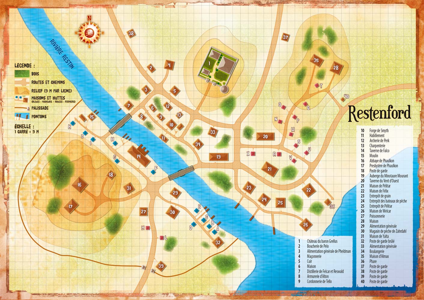
And our last map of the day is actually a birds-eye view from Dungeon Magazine #71, November 1998.

It was part of an adventure called "Priestly Secrets" that involves some goings-on at the old Abbey of Phaulkon several years after the action of L2 Assassin's Knot. It's a slightly simplified version of Restenford with some extraneous buildings removed, which is fine by me. It does a great job of showing space and scale and the topography of the region and takes liberties to make the town look more human than the ham-handed building layouts of the original module would have you believe. Also, that portion of the village on the north bank is now enclosed by a palisade and the Baron's castle has been improved a bit--the new Baron seems to have a better handle on administering the physical plant than his (or her) predecessor had. Plus, there's that odd seawall thing off the shore; what's that all about? A tsunami early warning structure? The gnome's new lighthouse? I don't recall any mention of this structure in the adventure, but it's such a quirky feature that it seems appropriate, in the grand Lakofkian tradition, that it is left unexplained.